
The 2023 Maui Wildfires serve as a powerful reminder of the devastation that such events can inflict on communities. Beyond the immediate destruction of homes and landscapes, wildfires release harmful pollutants into the air, posing serious health risks that can persist long after the flames are extinguished.
Understanding how air pollutants spread is crucial for crafting effective responses and strategies for future wildfire events. By mapping wind speed and direction, we aim to explore the complex patterns of how airborne pollutants travel and make their way into homes. This data is important for several reasons.
- Helps us understand the immediate spread of wildfire-associated pollutants across different geographical areas
- Provides insights into wind behavior to guide effective response strategies and public communication
- Inform detailed analyses of the relationship between outdoor and indoor pollution levels, aiding in the assessment of building ventilation systems and infiltration rates of pollutants.
By making this critical wind data publicly accessible, we aim to empower researchers and policymakers in related fields, enabling a proactive approach to protecting communities against future wildfires. Our collective efforts underscore a fundamental objective: to build resilient landscapes and communities that prioritize health and safety in the face of natural disasters. We’re committed to making this data available to the public to promote further research and protect both communities and the environment.
You can access the Maui Wind Data Maps and raw data from the following link:
https://dataverse.harvard.edu/dataset.xhtml?persistentId=doi:10.7910/DVN/YQPWKG
About the models:
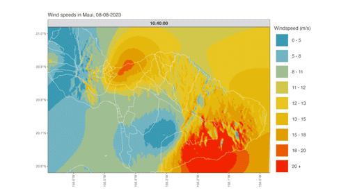
Our partners at the University of Hawai’i at Manoa created detailed wind maps for the Lahaina region during the August 2023 wildfires. These maps were crafted using the Maui Digital Elevation Model (DEM), which provides an accurate representation of the land’s topography, excluding trees, buildings, and other surface objects. WindNinja, a diagnostic wind model developed for wildland fire modeling, was used to simulate wind speed and direction.
The data is organized by each day in August 2023, with individual .zip files containing .kmz files that can be viewed on Google Earth. For ease of use, an R script is included in the repository to convert these files into a .csv format, with detailed instructions available in the README file.